
In the early hours of November 1, 2022, one of the largest ever recorded ice avalanches caused the tongue of Bukadaban Feng glacier, located at the highest peak of the Kunlun Mountains in Tibet, to break off. Roughly 40 million cubic metres of ice, equivalent to 16,000 Olympic swimming pools, slid into the lake below, turning a sluggish glacier into a violent hazard.
Located deep inside a nature reserve and far from any population, the glacier’s collapse remained unnoticed and caused no injuries. It wasn't until two years later, during a routine analysis of satellite observations, that scientists discovered the glacier’s long, narrow extension, known as the glacier tongue, had vanished. In a study published by researchers contributing to ESA-funded climate research, scientists reconstructed the entire event using satellite observations. Sudden detachments of entire glacier tongues are rare but potentially devastating events. Glaciers provide a clear indication that our climate is changing and exhibit a more or less synchronous loss of ice. This has implications for regional fresh water resources, including the Himalayan basin, and on sea level rise. Glacier surges, a sudden speeding up of the glacier’s flow speed, and collapses are poorly understood and seem to increase in frequency. They pose a natural hazard while also accelerating ice loss, making glaciers more vulnerable to climate warming; in a changing climate the timing and location of surges may change and act as a sensitive indicator of climate shifts in cold regions. This is why we need global long term continuous records.
Why remote glacier surges should concern us
An ice avalanche in an uninhabited plateau might seem like a distant incident, but it points to a broader pattern. As global temperatures rise, glacier instability could be increasing, and not always in remote places. The rock-and-ice avalanche near Blatten, Switzerland in May 2025 is a severe reminder of what is at stake when glaciers fail near communities.
Collapses like this one occur when a so-called stability tipping point is reached. A stability tipping point is a threshold beyond which the earth system, such as coral reef die-off, collapse of ice sheets and glaciers or forests becoming net carbon emitters, changes rapidly and irreversibly. While climate tipping points affect entire regions, local tipping points can affect single glaciers, for instance their stability. Once crossed, the glacier does not simply recover, but the loss sets further processes in motion. Melting ice exposes darker ground, which absorbs more heat, which drives more melting. These feedback loops are at the heart of why scientists treat glacier loss not just as a consequence of climate change, but as something that actively accelerates it. The behaviour of surge-type glaciers is still poorly understood, yet pose real risks for natural hazards and sea-level rise projections which is why they are the focus of the CCI Glaciers and Cross-ECV Karakorum Anomaly projects.
Recreating the ice avalanche from space
With no instruments on the ground, researchers turned to seismic records from stations across eastern Tibet to pinpoint the collapse to 05:55 UTC on 1 November 2022, which was confirmed using before-and-after satellite imagery.
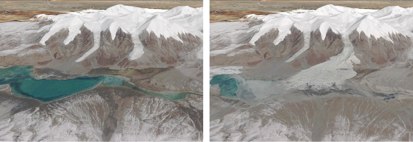
The analysis of the data revealed some interesting details. The ice blocks that reached the lake were surprisingly large and intact, measuring 15 to 20 metres in length. This suggested that the glacier tongue had essentially glided downhill with very little friction. The impact generated a 13-metre wave that swept nearly 800 metres across the lake shores.
The warning signs were already there
In the months before the collapse, the glacier was already showing signs of surging. Its normal daily flow was around 0.2 metres. By summer 2022, it had accelerated to 26 metres, reaching 46 metres per day in the days before the collapse. Unusually warm temperatures and ice-melt rates are thought to have triggered the event. Between May and August 2022, daily average temperatures in the area were nearly 4°C above the long-term average and consistently above zero degrees. Meltwater is thought to have seeped beneath the ice, reducing friction and triggering a runaway acceleration until the glacier tongue gave way entirely.
“So far, glacier detachments like the one investigated here happened during the melt season. It is one of the new findings of our study, and also important for hazard management, that glacier instability can propagate far into the cold season so that complete failure happens under freezing conditions. Our study also demonstrates impressively how much we can reconstruct and learn about events back in time, thanks to the multitude of different and systematic satellite data openly available, even over the most remote regions on Earth.”, Andreas Kääb explains.
Can we predict the next glacier avalanche?
There is cautious reason for optimism. A recent study by Smith et al. (2026) has developed methods to identify sudden changes in the earth system, such as the Amazon Forest and glacier surges. Their study suggests that glacial surges like the one seen in Tibet may be detectable up to one to two years in advance. By tracking subtle shifts in a glacier's behaviour over time and applying statistical analysis, the method successfully identified warning signals before surges occurred on two glaciers, one in Alaska, one in the Karakoram region of the Himalayas. In particular satellite radar interferometry is able to detect the very onset of glacier surges by identifying tiny disturbances of the else smooth deformation of glaciers (Mannerfelt et al., 2025).
In the scope of resilience monitoring and early warning systems, the ESA project SIRENE is dedicated to improve the detection and prediction of climate tipping points. To further this work, ESA has also launched six new projects dedicated to investigating different tipping elements of the climate system. One intriguing focus area is the Karakoram Anomaly, a puzzling phenomenon as the glaciers in this area are among the only glaciers in the world currently growing rather than shrinking, which ESA is investigating through the dedicated Cross-ECV Project Karakoram Anomaly. Findings like these feed into the broader work of ESA CCI, which develops long-term satellite-derived Climate Data Records for key aspects of the climate. Used in combination, these records help to address scientific challenges, deepen our understanding of the climate, detect anomalies, observe tipping points and support the development of early warning systems as well as plans for mitigation and adaptation to the changing climate.