Summary
The project is studying the present day and future evolution of the two polar ice sheets and their contribution to sea level rise. The mass budget of the ice sheets and sea level rise are key challenges in climate science, identified as priority targets in the most recent IPCC sixth assessment report (AR6).
PISCO will advance our understanding of key processes that drive uncertainty in projected changes in the ice sheet mass budget over Greenland and Antarctica. To do this it brings together climate scientists and satellite experts to leverage the potential of, and exploit synergies from, satellite-based climate data products (Essential Climate Variables, ECVs) together with the latest generation high-resolution climate simulations of the Arctic and Antarctic.
Project Background
The large ice sheets are an interactive part of the Earth system, being built up of compressed snowfall over millennia, and melted by both a warming atmosphere, where cloud properties play a key role in moderating the surface energy and moisture budgets, as well as warm ocean currents. In turn the ice sheets contribute large freshwater fluxes, both solid and liquid to the oceans, as well as having a controlling role in the polar regional climate via high surface topography with steep sides and a cold, white surface that acts both reflectively and as an energy sink.
The Antarctic and Greenland ice sheets contain an equivalent of 58m and 7m of global sea level rise, respectively. They are the largest single sources of potential sea-level rise, and significant contributors to already observed rise contributing 21.0±1.9 mm since the 1990s (Otosaka et al, 2023). Even the current modest losses from these ice sheets have increased coastal flooding and future losses will also likely affect ocean circulation through freshwater input. The future evolution of the ice sheets is a key climate uncertainty identified in the most recent IPCC reports (Bamber et al , 2022), as there are significant differences between different models, even when forced using the same pathways ( Goelzer et al., 2020; Seroussi et al., 2020).
Despite their crucial role in the polar climate system, ice sheets—particularly in Antarctica—remain poorly sampled by in situ measurements. Surface processes and surface-atmosphere interactions are often oversimplified in global climate models due to the logistical challenges of working in these remote environments. As a result, Earth Observation (EO) data have become essential for understanding ice sheet mass balance, especially over large areas and extended time periods. Thanks to the initiative CCI, EO datasets have grown significantly in the past decade, offering standardized, quality-controlled observations. These data are now well-suited for studying physical processes, evaluating climate models, and gaining insights into ice sheet dynamics and their role in the broader Earth system. Therefore, connecting EO data alongside next-generation climate and weather models offers strong potential to reduce uncertainties in both current extreme weather patterns and future climate projections.
A core aim of PISCO is to enhance cooperation and development between satellite and RCM research groups to promote greater use of EO datasets for research in the future (both inside and outside of the Polar Regions), as well as investigating the uncertain future of ice sheet mass budget processes.
Project aims and objectives
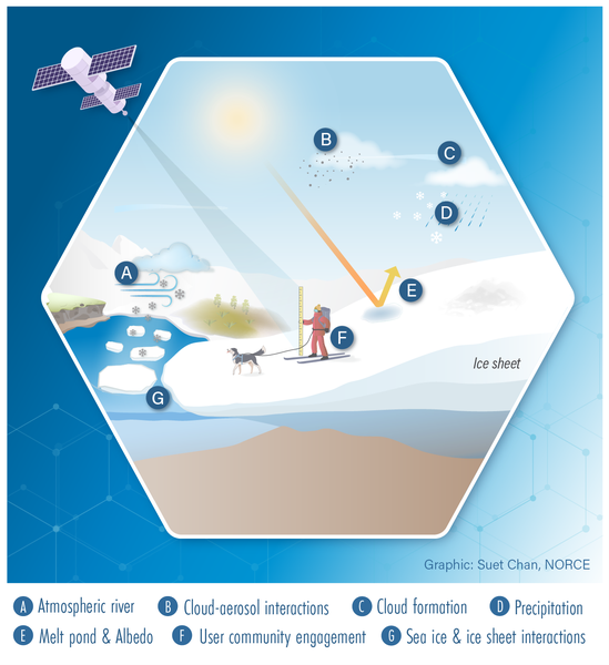
PISCO aims at reducing uncertainties in future sea level projections and improve how climate models represent polar regions. PISCO brings together climate scientists and satellite experts to combine cutting-edge satellite observations with high-resolution regional climate models with the objective to better understand four key processes:
- Precipitation and Extreme Weather
PISCO will explore how different types of precipitation events - including extreme events - affect ice sheet mass balance, using a combination of satellite data, weather models, and surface elevation change estimates (including firn densification estimates from Regional Climate Models (RCMs)).
PISCO will use EO and reanalysis data to identify climate extremes over the historical period 2001-2020, complemented with the application of the novel tracking tool: Multi-Object Analysis of Atmospheric Phenomenon (MOAAP) algorithm. - Polar Clouds and Aerosols
PISCO will investigate how aerosols influence cloud formation and how that, in turn, affects surface melting. The project will use ESA CCI products both to evaluate cloud and aerosol processes as well as explore the possibilities of using the products to achieve better initialisation of the regional climate model and introduce more consistent temporal variability. - Sea Ice and Snowfall
As sea ice retreats and oceans warm, atmospheric conditions change near the ice sheets. PISCO will study how those shifts impact snowfall patterns and accumulation around Antarctica. PISCO will take advantage of both high spatial and temporal resolution model outputs and high spatial resolution SIC (Sea Ice Concentration) data, along with a long timeseries of GMB (Gravimetric Mass Balance) data to assess if there is a causal relationship between sea ice extent and ice sheet mass budget on both a continental and a basin scale. - Surface Melting and Supraglacial Lakes
PISCO will look into how well models capture the extent of surface melting on the ice sheets, and try to identify key biases - such as how surface brightness (albedo), snow density, and cloud representation affect melt.
PISCO is unique in the leading role played by state-of-the-art regional climate model simulations for the polar regions together with Earth Observation datasets, and a key objective is to advance technical and scientific developments that reduce barriers to the use of satellite data in the context of models.
Finally, towards the objective of building long-term relationships between research groups building EO datasets and those running RCMs, PISCO will foster closer working practices through outreach activities, including well documented open code notebooks and dedicated workshops.
Project plans
The PISCO project work is designed to cover three main aspects:
- Climate science challenges
- Technical and scientific developments to reduce barriers to the use of satellite date in the context of climate models
- Outreach
To this end, the project is organised into five Work Packages
- WP1: Science Requirements
The first WP of PISCO will draw on the expertise of both climate and satellite experts within the team to define the scientific requirements to fulfill the project. Furthermore, WP1 will also bridge with other teams within CCI with the aim to better integrate datasets within the regional climate modelling world. - WP2: ECV Data Preparation
WP2 will conduct essential tailoring of observational data, ensuring it meets the quality, structure, and scientific standards required for easy accessibility for climate modelling experts. As observational data often varies in format, resolution, and quality across different sources, it calls for harmonising the dataset through target tailoring. This phase will refine the dataset by performing regridding, reprojection, reclassification, quality filtering, and bias correction, each chosen to align the data with the study’s scientific objectives. - WP3: Scientific Analysis
WP3 is the largest task of PISCO, bringing together the regional climate model output with the EO data to address PISCO’s main scientific challenge: how to understand the processes that control SMB over the two ice sheets, how they compare with each other and what are significant biases or gaps in understanding.
The WP is divided into sub-WPs, to cover particular processes:- WP3.1: Scientific Challenge
- WP3.2: Clouds, aerosols and surface energy budget
- WP3.3: Atmospheric phenomena and extreme changes: precipitation, moisture transport and accumulation
- WP3.4: Impact of sea ice changes on ice sheet mass budget
- WP3.5: Melt area, surface lakes and melt ponds
- WP4: Outreach and User Engagement
Scientific and technical advances made in PISCO will be communicated widely to the climate modelling and Earth Observation communities and to the general public. WP4 will produce communication materials but also publish user documentation, an open science toolkit, and will organize a bootcamp/hackathon for Early Career Researchers and a dedicated PISCO workshop. - WP5: Project Management
Administrative and financial management to ensure a smooth collaboration, effective communication and timely submission of all deliverables and milestones.
2026
- Kolbe, M., Torres Alavez, J.A., Mottram, R. et al. Atmospheric rivers and winter sea ice drive recent reversal in Antarctic ice mass loss. Commun Earth Environ (2026). https://doi.org/10.1038/s43247-026-03242-3
Key contacts
Science Leader: Dr Ruth Mottram
Project Manager: Irene Robles Garcia
ESA Technical Officer: Dr Simon Pinnock (ESA)

Danish Meteorological Institute (DMI)
- Project role: Project Coordinator, lead: WP3.4, WP3.5, WP4, WP5

Norwegian Meteorological Institute (Met Norway)
- Project role(s): lead: WP1, WP3.2

NORCE Research AS (NORCE)
- Project role: lead: WP3 (WP3.1, WP3.3)

Technical University of Denmark, Department of Space Research and Technology (DTU-SPACE)
- Project role: lead: WP2 (WP2.1, WP2.2)