
Two essential Earth observation satellites are set to launch this November, ensuring an ongoing global monitoring of essential climate variables. The Copernicus Sentinel-1D and Sentinel-6B satellites will provide continuity of radar altimetry observations to monitor ice sheet movement, wave patterns, and sea level rise. Sentinel-1D was launched on November 4, and will be followed by Sentinel-6B later that month.
These missions will be instrumental in developing the long-term, multi-mission climate data records generated by ESA's Climate Change Initiative (CCI). The CCI conducts research and development to create pre-operational retrieval algorithms and processing systems for Essential Climate Variables (ECVs) defined by the Global Climate Observing System (GCOS), including Antarctic Ice Sheets, Greenland Ice Sheets, Glaciers, Land Cover, Biomass, Lakes and Sea State. By harnessing data from multiple missions and archives, the CCI ensures consistent, high-quality climate records, critical for understanding long-term climate trends and informing climate action.
Data continuity for climate research
The Copernicus Sentinels, developed by ESA, are the operational backbone of Europe's Copernicus programme, providing global, continuous, autonomous, high-quality, wide-range Earth observation. They deliver accurate, timely, and easily accessible information to improve the management of the environment, including climate. These new satellites will provide measurement continuity – essential for understanding and documenting long-term climate trends.
Launch details
The Sentinel-1 satellites are operated by the European Space Agency (ESA), while Sentinel-6 is a collaborative effort between ESA, the National Aeronautics and Space Administration (NASA), the National Oceanic and Atmospheric Administration (NOAA), and the European Organisation for the Exploitation of Meteorological Satellites (EUMETSAT). Full details of the launches are available on the Sentinel-1 and Sentinel-6 mission pages, and the launches can be followed live on the ESA Web TV page.

Continuing critical ice sheet monitoring
Sentinel-1D carries a C-band synthetic aperture radar (SAR), operating at a frequency of 5.405 GHz, allowing to see through clouds and rain to measure Earth's surface. This capability makes it invaluable for tracking our changing planet, particularly tropical forests and polar regions – both known for significant cloud coverage. Its observations will contribute to several climate data records used to address the ECVs. Scientists will use its data to improve algorithms and analyses related to waves, lake water levels, and changes in land cover and tropical forests.
According to the IPCC’s Sixth Assessment Report, global mean sea level is rising at an accelerating rate, driven by ice loss from the Greenland and Antarctic ice sheets, ongoing glacier mass loss and ocean thermal expansion. A recent study by ESA’s Glambie project revealed that the glacier loss between 2000 and 2023 contributed 18 mm to global sea level rise. Monitoring these changes is therefore an increasingly critical application.
The CCI Glaciers project team uses Sentinel-1 data to detect debris-covered glaciers that are otherwise invisible in optical images, identify sudden glacier surges and measure how fast glaciers are moving. Understanding glacier behaviour is critical not only because they provide vital freshwater resources, contribute to sea-level rise but also because glacier melt increases risks of landslides and glacier lake outburst floods, according to the IPCC Impacts, Adaptation and Vulnerability Report. Notably, while most glaciers worldwide are retreating, satellite measurements track anomalous behaviour such as glacier growth in the Karakoram region. The CCI Karakoram-Anomaly project is providing crucial insights into regional climate variations, investigating why the glaciers in this region behave differently from others. By gaining understanding of glaciers response to climate change, we are able to improve our climate models and therefore better predict future glacier behaviours in various regional conditions.
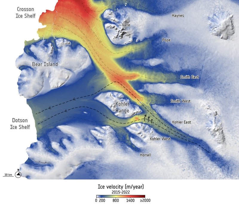
By joining Sentinel-1C which is already in orbit, Sentinel-1D will increase the constellation’s imaging frequency to once every 6 days. "Sentinel-1C and -1D will restore our ability to track sudden accelerations or collapses at glacier fronts and ensure we are able to continue to do so into the future" explains Dr. Tom Slater, Northumbria University, who is a lead scientist contributing to the CCI’s Antarctic Ice Sheet project. The project has already demonstrated the value of Sentinel-1 data with recent research revealing how an Antarctic glacier is stealing ice from its neighbour, highlighting the critical insights these satellites provide for understanding ice sheet dynamics.
Extending three decades of sea level measurements
The Sentinel-6 Michael Freilich satellite, launched in 2020, serves as the reference satellite for measuring the evolution of the sea surface height over the global ocean. As the first satellites to bring synthetic aperture radar measurement techniques into the reference altimeter time series, Sentinel-6 provides improved measurements of the sea state, wind speed, river and lake hydrology and will maintain the sea-level rise observations.
The Sentinel-6 satellites build upon a measurement legacy established by the TOPEX/Poseidon satellite in 1992 and continued through the Jason satellite series.
The upcoming Sentinel-6B will fly in tandem with its predecessor during a calibration period to maintain data consistency. "Once calibrated, the Sentinel-6B mission will ensure the continuity of the historical reference sea level measurements.” says Dr. Jean-François Legeais, coordinator of the CCI Sea Level project. "The Sentinel-6 mission improves accuracy compared to previous altimetry missions and allows the reduction of the uncertainties of the sea level trends and acceleration, which is essential to improve climate model projections and design climate adaptation strategies."
Multiple climate data records addressed by the CCI projects rely on Sentinel-6 data to track Earth’s changes in hydrology. The CCI Sea Level project uses it to refine measurements along coastlines, where a significant part of the world population is affected by the increasing sea level. The project researchers have already reprocessed two decades of sea level data from previous satellites, improving coastal data quality – where the impacts of sea level rise are most acutely felt. Additionally, they have developed a network of virtual coastal gauges, enabling sea level monitoring in locations without physical measurement stations, extending the vital data to previously unmonitored coastal communities.
With Sentinel-6B data, the team will further reduce uncertainties in sea level measurements and extend the long-term sea level time series. The Sea State project tracks wave heights and ocean surface conditions, while the Sea Level Budget Closure project pieces together all contributors to the rising seas. The Lakes and River Discharge projects use the Sentinel-6 data to monitor water levels inland, tracking how lakes shrink or expand with changing climate and measuring river flow rates across remote regions.
Continuity for the future
With the two launches in November, the new satellite generations will secure continuous observation of Earth's climate systems during a period of unprecedented environmental change. The uninterrupted data streams from Sentinel-1D and -6B will provide researchers with the long-term measurements essential for understanding climate dynamics and informing response strategies. These missions demonstrate Europe’s enduring commitment to sustain the global Earth observation infrastructure that underpins international climate action.
References
The GlaMBIE Team. Community estimate of global glacier mass changes from 2000 to 2023. Nature 639, 382–388 (2025). https://doi.org/10.1038/s41586-024-08545-z
Selley, H. L., Hogg, A. E., Davison, B. J., Dutrieux, P., and Slater, T.: Speed-up, slowdown, and redirection of ice flow on neighbouring ice streams in the Pope, Smith, and Kohler region of West Antarctica, The Cryosphere, 19, 1725–1738, https://doi.org/10.5194/tc-19-1725-2025, 2025.