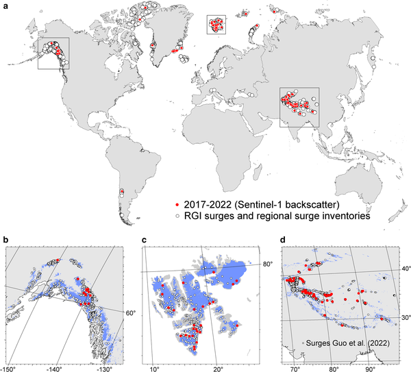
Glacier surge events, the sudden and rapid acceleration in ice flow rate presents a transient yet potentially hazardous risk to local communities. For the first time, scientists have mapped these events on a global-scale using satellite-based observation and research.
The study published in the Journal of Glaciology identified 115 glacier surge events following an analysis of archived data during 2017-2022, with most of these events concentrated in three regions, the Tibet plateau, Svalbard in Norway, and Yukon in Alaska.
Knowing where and when glaciers surge is important for understanding the impacts of climate as these event disturb the direct link between climate and glacier mass and length changes.
The research team analysed flow velocity time series derived from Sentinel-1 combined with visual analysis of Sentinel-2 images over the period 2017-2022 using retrieval algorithms developed as part of ESA’s the Climate Change Initiative.
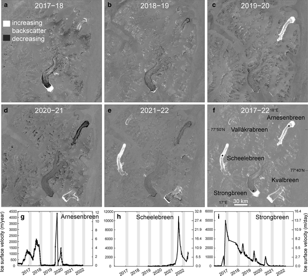
The researchers, comprising scientists from the University of Oslo in Norway and Switzerland-based Gamma Remote Sensing, exploited the ability of C-band Synthetic-Aperture Radar (SAR) instrument on-board the Copernicus Sentinel-1 satellite to detect changes in roughness across a glacier’s surface.
During a surge event, ice can flow 10 to 100 times faster than normal. The stresses on the ice result in a network of deep fractures. Using Sentinel-1 the researchers were able to detect this change during the day, even under cloudy conditions, and at night, with the increased backscatter appearing brighter than images that capture glaciers moving at a more typical pace.
To confirm their method, and rule out other events that impact glacier surface roughness, such as snow avalanches, the researchers compared affected areas using optical imagery from Sentinel-2.
Andreas Kääb, lead author of the study, explains, “This is the first time that glaciers surges have been mapped globally in a consistent way, and including timing information to show when these events happened. This gives us a number of new insights and possibilities for further research. In my view, though, the most surprising result is that the discovered surges were concentrated in just a few areas.
The approach reveals interesting dynamics of glaciers on a global scale. While the authors suggest the clustering of these events may point to large-scale meteorological or climatic influences on surge timing but highlight that the short - five-year - observation period is too short to exclude with certainty other possible effects such as random interference of surge cycles or spatial biases in our surge detection approach.
“While climate change – in particular rising air temperatures and changes in snow fall – could have caused the geographic surge clusters that we found, we need longer time series of glacier surge maps to closer investigate this theory. The long-term perspective and consistency of the Copernicus Sentinel missions is therefore of key importance for us,” adds Professor Kääb.
The project was supported by ESA’s Climate Change Initiative, a major research and development programme which is generating satellite-derived observation records for a suite of Essential Climate Variables, including glaciers, and research to support the development of actionable information for policy formulation, decision-making.


